
Sárbogárd
This article needs additional citations for verification. (April 2021) |
Sárbogárd | |
|---|---|
 Sárhatvan Chapel of Sárbogárd | |
 Flag  Coat of arms | |
 Sárbogárd Location of Sárbogárd | |
| Coordinates: 46°53′16″N 18°37′10″E / 46.88776°N 18.61932°E | |
| Country | |
| County | Fejér |
| District | Sárbogárd |
| Area | |
| • Total | 189.34 km2 (73.10 sq mi) |
| Population (2009) | |
| • Total | 12,922 |
| • Density | 68/km2 (180/sq mi) |
| Time zone | UTC+1 (CET) |
| • Summer (DST) | UTC+2 (CEST) |
| Postal code | 7000 |
| Area code | (+36) 25 |
| Website | www |
Sárbogárd (German: Bochart) is a town in Fejér county, Hungary. The town is at the intersection of important railroad routes in Hungary: this is where electrified routes from Balaton and Pécs merge with non-electrified railways from Baja and Szekszárd. A double electrified track runs from Sárbogárd to Budapest allowing MÁV trains to provide quick access to the capital.
Twin towns — sister cities[edit]
Notable people[edit]
- Zoltán Lengyel (1960–), politician
- Géza Mészöly (1844–1887), Romantic painter
- Lajos Májer (1956–1998), footballer
- Béla Jurcsek (1893–1945), politician, Minister of Agriculture
- Gábor Varga (1968–), politician
Gallery[edit]
-
 The map of Sárbogárd from the First Military Mapping Survey of Austria Empire
 -
 The map of Sárbogárd from the Second Military Mapping Survey of Austria Empire
 -
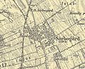 The map of Sárbogárd from the 3rd Military Mapping Survey of Austria Empire


References[edit]
- ^ "Testvértelepüléseinkről". sarbogard.hu (in Hungarian). Sárbogárd. Retrieved 2021-04-09.
External links[edit]
Wikimedia Commons has media related to Sárbogárd.
- Official website in Hungarian
| Town (1) |
| |
|---|---|---|
| Large village (1) | ||
| Villages (10) | ||


| International | |
|---|---|
| National | |
This Fejér location article is a stub. You can help Wikipedia by expanding it. |